Marine GPS: The Ultimate Guide to Navigation at Sea
In today’s era of advanced maritime technology, Marine GPS (Global Positioning System) stands as an essential tool for anyone navigating the open waters. Whether you’re a professional mariner, a weekend boater, or a fishing enthusiast, a marine GPS system can dramatically improve your safety, efficiency, and overall boating experience.
This comprehensive guide explores everything you need to know about marine GPS, including how it works, key features to look for, benefits, top brands, and frequently asked questions.
What Is a Marine GPS?
A Marine GPS is a specialized navigation device designed for marine environments. It uses satellite signals to determine the precise location, speed, and direction of a vessel in real-time. Unlike standard GPS units, marine GPS devices are built to withstand harsh ocean conditions such as saltwater, humidity, and constant movement.
How Does Marine GPS Work?
Marine GPS works by receiving signals from a network of satellites orbiting the Earth. By calculating the time it takes for these signals to reach the GPS receiver, the device can determine your exact location within a few meters. Marine GPS units often come integrated with chartplotters, fish finders, sonar, and other marine instruments for enhanced functionality.
Why Marine GPS Is Important
Navigating at sea without GPS is like driving in the dark without headlights. The marine environment is constantly changing, with no road signs or landmarks. Here’s why marine GPS systems are indispensable:
1. Accurate Navigation
Marine GPS ensures you always know your exact location, helping you navigate safely and efficiently.
2. Route Planning
You can pre-plan your journey by marking waypoints and creating navigational routes.
3. Safety
In emergencies, knowing your coordinates can assist rescue teams in locating your vessel quickly.
4. Fishing and Exploration
GPS can mark the best fishing spots or dive sites so you can return to them later.
Types of Marine GPS Devices
There are several types of GPS devices tailored to different needs:
1. Handheld Marine GPS
-
Portable and battery-powered
-
Ideal for kayakers, small boats, or as backup
-
Waterproof and rugged design
2. Fixed-Mount Marine GPS
-
Installed on the dashboard or helm
-
Offers large, high-resolution screens
-
Often integrated with radar, sonar, and autopilot systems
3. Chartplotters
-
Combines GPS with digital nautical charts
-
Allows you to plot and follow routes
-
Provides overlays like depth contours and buoy markers
4. Multifunction Displays (MFDs)
-
Central hub that integrates GPS, sonar, radar, and more
-
Touchscreen displays with customizable layouts
-
Ideal for serious anglers and offshore cruisers
Key Features to Look For in a Marine GPS
When choosing the best marine GPS system, consider the following features:
1. Waterproof Rating
Look for IPX7 or higher waterproof ratings to ensure durability.
2. Display Quality
Choose a screen that is sunlight-readable with high resolution for clear visibility.
3. Preloaded Charts
Devices with preloaded charts (e.g., BlueChart, Navionics) provide instant access to mapping data.
4. Chart Updates
Ensure the unit supports regular updates for the latest navigational data.
5. Waypoints and Routes
The ability to save waypoints and routes is crucial for route planning and return trips.
6. AIS Integration
AIS (Automatic Identification System) integration enhances safety by displaying nearby vessel information.
7. Sonar/Fish Finder Compatibility
For anglers, sonar integration helps locate fish and underwater structures.
8. Wireless Connectivity
Bluetooth or Wi-Fi allows easy syncing with mobile devices and apps.
9. Battery Life (for handheld units)
Opt for long-lasting batteries and fast charging capabilities.
Top Marine GPS Brands
Several trusted brands dominate the marine GPS market:
1. Garmin
-
Industry leader with reliable GPS, sonar, and chartplotters
-
Models like Garmin GPSMAP and ECHOMAP are highly rated
2. Raymarine
-
Known for robust multifunction displays and radar integration
-
Offers high-end systems suitable for large vessels
3. Simrad
-
Popular among fishermen and offshore boaters
-
Advanced features with intuitive interfaces
4. Lowrance
-
Focuses on fishing-oriented GPS units with sonar integration
-
Great for inland and coastal fishing
5. Humminbird
-
Specializes in GPS and fish finders for freshwater and saltwater anglers
Marine GPS vs. Smartphone GPS Apps
While smartphone GPS apps are convenient, they are no substitute for a dedicated marine GPS device:
| Feature | Marine GPS | Smartphone GPS App |
|---|---|---|
| Waterproof | Yes | No (unless protected) |
| Battery Life | Long | Short |
| Satellite Reliability | High | Variable |
| Chart Integration | Yes | Limited |
| Sonar/Fish Finder | Yes | No |
| AIS Compatibility | Yes | No |
Conclusion: Use smartphone apps for backup, but always rely on a marine GPS for serious navigation.
Installing a Marine GPS System
Here are the basic steps to install a fixed-mount marine GPS:
-
Choose a Mounting Location: Preferably near the helm for easy access and visibility.
-
Connect to Power Supply: Usually via the boat’s 12V system.
-
Install Antenna (if required): Some units have external GPS antennas for better signal.
-
Mount Transducers (for sonar): Below the waterline for accurate sonar readings.
-
Configure Settings: Set up charts, units (knots, nautical miles), and waypoints.
-
Test the System: Ensure everything works before setting sail.
For complex setups, professional installation is recommended.
Benefits of Using a Marine GPS
Using marine GPS offers both peace of mind and enhanced performance on the water:
✔ Improved Navigation
Easily follow plotted courses, even in poor visibility.
✔ Faster Emergency Response
Transmit exact coordinates in case of man-overboard or mayday scenarios.
✔ Optimized Fuel Efficiency
Take the most efficient route to reduce travel time and fuel usage.
✔ Better Fishing Results
Mark hotspots and analyze underwater terrain with sonar overlays.
✔ Trip Logging
Keep detailed records of your voyages for future reference or legal documentation.
Popular Marine GPS Models in 2025
Here are a few top-selling models in 2025:
-
Garmin GPSMAP 8612xsv
-
12″ HD touchscreen
-
BlueChart G3 coastal maps
-
Supports radar, sonar, and autopilot
-
-
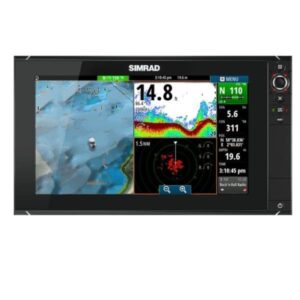
Simrad GO9 XSE
-
9″ MFD with CHIRP sonar
-
Radar and AIS compatibility
-
Easy to use interface
-
-
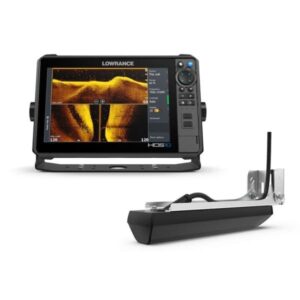
Lowrance HDS PRO 10
-
Targeted at anglers
-
High-resolution imaging and Live Sonar
-
Excellent depth-finding features
-
-
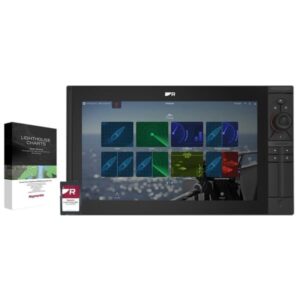
Raymarine Axiom 7
-
Compact but powerful
-
Lighthouse 4 operating system
-
RealVision 3D sonar support
-
Marine GPS Maintenance Tips
To ensure longevity and accuracy, follow these maintenance practices:
-
Clean the screen regularly with microfiber cloths.
-
Update firmware and charts frequently.
-
Check power cables and connectors for corrosion.
-
Store handheld devices in a dry, secure location.
-
Test before trips to catch any malfunctions early.
Frequently Asked Questions (FAQs)
Q1: Can I use a car GPS for my boat?
No. Car GPS units are not waterproof, do not display marine charts, and lack AIS or sonar support.
Q2: Are marine GPS systems expensive?
Prices range from $100 for basic handheld units to $3,000+ for multifunction systems. Choose based on your boating needs.
Q3: Do I need internet for marine GPS to work?
No. Marine GPS uses satellite signals and works offline. However, updates and syncing may require internet access.
Q4: What is the difference between GPS and chartplotter?
GPS tells your location, while a chartplotter overlays that location on a digital nautical map for route planning and navigation.
Q5: How often should I update charts?
It’s best to update your charts every 6-12 months or before major voyages.
Marine GPS
Showing 1–30 of 48 results
-
Marine GPS
Garmin GPSMAP 8417 MFD With Worldwide Basemap
GPSMAP 8417 large-format multifunction display features a 17-inch full HD screen with touch control. Sunlight-readable, anti-glare display is exceptionally easy to view and also includes auto-dimming feature for use in low light or at night. The maximum glass design enables you to experience a beautifully powerful, completely networked helm at your fingertips.
SKU: n/a -
Marine GPS
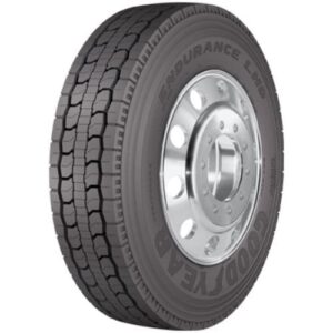
Goodyear Marathon LHD 11R24.5 H/16PLY
When it comes to long-haul trucking, the choice of tire can significantly impact your vehicle’s performance, fuel efficiency, and overall safety. The Goodyear Marathon LHD 11R24.5 H/16PLY is a top-tier drive tire specifically engineered for long-distance freight operations. Built for durability, reliability, and fuel economy, this tire is a favorite among fleet managers and independent truckers alike.
SKU: n/a -
Marine GPS
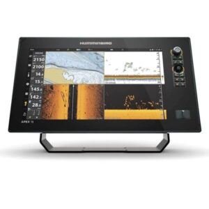
Humminbird APEX 16 MEGA SI Plus CHARTPLOTTER
The APEX 16 MEGA SI Plus CHARTPLOTTER provides the clearest sonar imaging on the sharpest multi-function display that anglers have ever seen. Industry-leading MEGA Imaging and Dual Spectrum CHIRP sonar come standard, with even more performance from a dedicated sonar channel for accessory 2D CHIRP transducers
SKU: n/a -
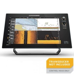
Marine GPS
Humminbird APEX 16 MEGA SI Plus CHARTPLOTTER CHO
In the world of advanced fishing and marine navigation, few names stand out like Humminbird. Known for cutting-edge sonar technologies and innovation, Humminbird’s APEX series has revolutionized the way anglers experience the water. Among the elite devices in this lineup is the Humminbird APEX 16 MEGA SI+ Chartplotter CHO—a powerhouse of precision, clarity, and integration.
SKU: n/a -
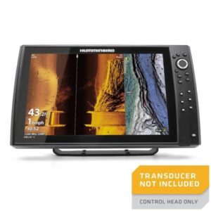
Marine GPS
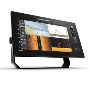
Humminbird Apex 19 Mega SI Plus CHARTPLOTTER
In the world of advanced marine electronics, the Humminbird Apex 19 Mega SI+ Chartplotter stands out as a cutting-edge powerhouse. Designed for serious anglers and professional mariners, the Apex 19 delivers an unmatched combination of precision, imaging technology, and seamless connectivity. With its large 18.5-inch full-HD touchscreen, ultra-detailed sonar imaging, and integrated GPS capabilities, the Apex 19 Mega SI+ takes navigation and fish-finding to a whole new level.
SKU: n/a -
Marine GPS
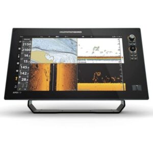
Humminbird APEX 19 MEGA SI Plus CHARTPLOTTER CHO
The APEX 19 MEGA SI Plus CHARTPLOTTER CHO provides the clearest sonar imaging on the sharpest multi-function display that anglers have ever seen. Industry-leading MEGA Imaging and Dual Spectrum CHIRP sonar come standard, with even more performance from a dedicated sonar channel for accessory 2D CHIRP transducers up to 2kW.
SKU: n/a -
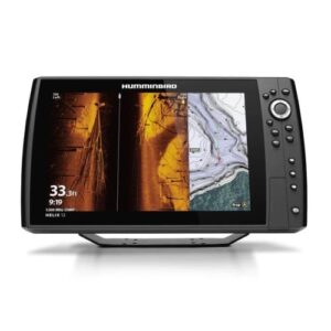
Marine GPS
Humminbird HELIX 15 CHIRP MEGA SI GPS G4N CHO
The Humminbird HELIX 15 CHIRP MEGA SI GPS G4N CHO is a state-of-the-art fish finder designed to elevate your angling experience. Packed with advanced features like MEGA Imaging, CHIRP sonar, and GPS navigation, it’s the ultimate tool for anglers who demand precision and performance on the water.
SKU: n/a -
Marine GPS
Humminbird HELIX 15 CHIRP MSI Plus GPS G4N
The HELIX 15 CHIRP MSI Plus GPS G4N CHO features a 15.4″ display, MEGA Side Imaging , MEGA Down Imaging , Dual Spectrum CHIRP Sonar and internal GPS with Humminbird Basemap. As with all HELIX G4N models, this HELIX 15 includes standard features such as AutoChart Live, Wi-Fi and NMEA 2000®, in addition to Bluetooth® and Ethernet networking for compatibility with the One-Boat Network™ family of products from Humminbird, Minn Kota and Cannon.
SKU: n/a -
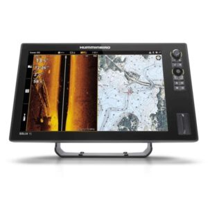
Marine GPS
Humminbird SOLIX 15 CHIRP MEGA SI Plus G3
For anglers who want nothing but the best in marine electronics, the Humminbird SOLIX 15 CHIRP MEGA SI+ G3 stands out as one of the most advanced and powerful fish finders available. Built with top-of-the-line sonar technology, GPS navigation, and an intuitive touchscreen interface, the SOLIX 15 G3 is designed for those who demand precision, performance, and detail on the water.
SKU: n/a -
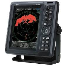
Marine GPS
ICOM MR-1010RII Marine Radar
Marine radar systems are essential for safe navigation, especially in low visibility conditions such as fog, nighttime, or storms. Among the most reliable marine radar solutions available today is the ICOM MR-1010RII Marine Radar. Known for its durability, precision, and user-friendly interface, this radar system is a popular choice for both recreational boaters and commercial vessels.
SKU: n/a -
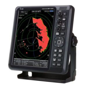
Marine GPS
ICOM MR-1220 Marine Radar
When it comes to reliable marine communication and navigation equipment, ICOM is a name synonymous with innovation and durability. Among its notable products, the ICOM MR-1220 Marine Radar stands out as a highly advanced, user-friendly marine radar system tailored to meet the needs of professional and recreational mariners alike. Whether navigating busy commercial routes or coastal waters, the MR-1220 offers exceptional performance in detection, clarity, and integration capabilities.
SKU: n/a -
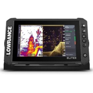
Marine GPS
Lowrance Elite FS 9 with Active Imaging 3-in-1
Buy New Lowrance Elite FS 9 with Active Imaging 3-in-1 for sale online, If you’re an angler or a boating enthusiast looking to enhance your fishing experience, the Lowrance Elite FS 9 with Active Imaging 3-in-1 is one of the most advanced fishfinder/chartplotter combinations available today.
SKU: n/a -
Marine GPS
Lowrance Elite FS 9 with Active Target Live Sonar No Transducer
In the world of modern fishing, advanced sonar technology has revolutionized the way anglers find and catch fish. One of the most talked-about devices in this arena is the Lowrance Elite FS 9 with Active Target Live Sonar No Transducer package. This system blends advanced functionality, real-time sonar imaging, and seamless networking capabilities—yet it raises questions for potential buyers when it comes without a transducer.
SKU: n/a -
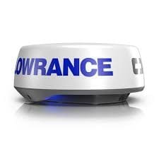
Marine GPS
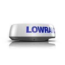
Lowrance HALO20 Plus Radar
In the world of marine electronics, radar technology plays a crucial role in ensuring navigation safety, especially in low visibility conditions. Among the top contenders in this category is the Lowrance HALO20 Plus Radar, a compact yet powerful marine radar that delivers high-performance target detection, real-time tracking, and intuitive functionality. Whether you’re cruising along the coast, fishing offshore, or navigating busy harbors, the Lowrance HALO20+ offers essential capabilities packed in a sleek, low-profile dome.
SKU: n/a -
Marine GPS
Lowrance HALO24 Plus Radar
In the fast-evolving world of marine electronics, Lowrance HALO24 Plus Radar stands out as a top-tier solution for navigation and collision avoidance. With cutting-edge solid-state pulse compression, 60 RPM high-speed rotation, and simultaneous dual-range capabilities, this marine radar offers unmatched clarity, safety, and functionality. Whether you’re a weekend angler, commercial fisherman, or long-range cruiser, the Lowrance HALO24+ is built to elevate your marine experience.
SKU: n/a -
Marine GPS
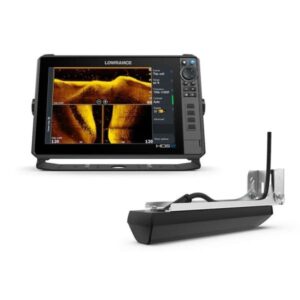
Lowrance HDS PRO 12 with Active Imaging HD
Lowrance HDS PRO 12 with Active Imaging HD, See more and catch more with the new HDS PRO fishfinder/chartplotter. Watch fish react to your lure live with new, high-resolution ActiveTarget® 2 Live Sonar, and find fish and holding structure with new, ultra high-definition Active Imaging™ HD.
SKU: n/a -
Marine GPS
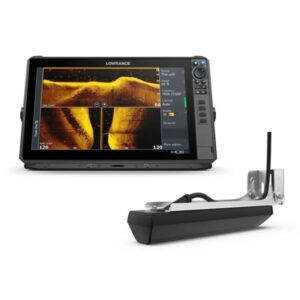
New Lowrance HDS PRO 10 with Active Imaging HD – Sale !!
See more and catch more with the new HDS PRO fishfinder/chartplotter. Watch fish react to your lure live with new, high-resolution ActiveTarget® 2 Live Sonar, and find fish and holding structure with new, ultra high-definition Active Imaging™ HD.
SKU: n/a